Travel Guide of Kaneohe in United States by Influencers and Travelers
Kāneʻohe is a census-designated place included in the City and County of Honolulu and located in Hawaiʻi state District of Koʻolaupoko on the island of Oʻahu. In the Hawaiian language, kāne ʻohe means "bamboo man".
The Best Things to Do and Visit in Kaneohe
TRAVELERS TOP 10 :
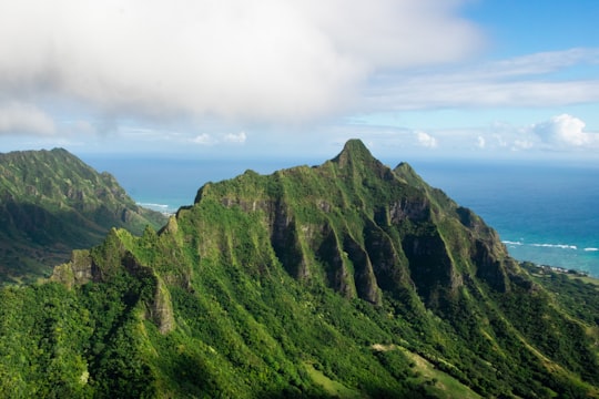
1 - Haiku Stairs
The Haʻikū Stairs, also known as the Stairway to Heaven or Haʻikū Ladder, is a steep, steel step structure that provided pedestrian access to former U.S. Navy communication facilities on the island of Oʻahu, Hawaii. The more than 3,000 steps span along Oahu's Ko'olau mountain range. The pathway has been used as a hiking trail at various times but is not open to the public. The city council voted to remove the stairs in 2021.
Learn more Book this experience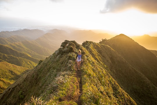
2 - Nu‘uanu Pali
Nuʻuanu Pali is a section of the windward cliff of the Koʻolau mountain located at the head of Nuʻuanu Valley on the island of Oʻahu. It has a panoramic view of the windward coast of Oʻahu.
View on Google Maps Book this experience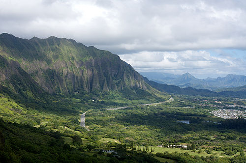
3 - Sea Kayaking in Oahu
6 km away
Head off on your very own adventure to the fabled island of Mokoli'i Island, from Kailua, Oahu! After dropping by the Active Oahu storefront in Kailua to pick up your kayaks, life vests, and drybags, the team will give you a kayaking lesson, sa...
Book this experience
4 - Lanikai Beach
9 km away
Lanikai Beach is located in Lanikai, a community in the town of Kailua and on the windward coast of Oahu, Hawaii. Although there is a widespread belief that the name Lanikai means "heavenly sea", that is a misconception and a grammatical error, since in the Hawaiian language, the qualifier comes after the noun.
Learn more Book this experience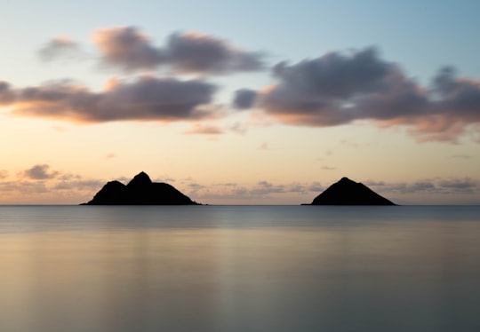

5 - Kailua
6 km away
Kailua is a census-designated place in Honolulu County, Hawaii, United States. It lies in the Koʻolaupoko District of the island of Oʻahu on the windward coast at Kailua Bay. It is in the judicial district and the ahupua'a named Ko'olaupoko. It is 12 miles northeast of Honolulu – over Nu‘uanu Pali. The population was 38,635 at the 2010 census.
Learn more
6 - Tours & Sightseeing | Hawaii City Tours
12 km away
Witness a scenic sunset over the beautiful city, Waikiki, from a new oceanic perspective aboard the Haleiwa Queen. Join a friendly crew as the sky transforms into a vibrant canvas of colors over downtown Honolulu during this sunset tour. Look through the glass-bottom viewports and witness the underwater world come alive with fish and sea life illuminated by the boat's lights. Even after dusk, Oahu's reefs offer a fascinating view. Add in the twinkling city lights of Honolulu reflected on the water, and you've got an unmatched experience. Whether you're on a family vacation or a group adventure, a tour with Hawaii Glass Bottom Boats is the perfect addition to your Hawaiian getaway.
Book this experience
7 - Mānoa
9 km away
The University of Hawaiʻi at Mānoa is a public research university in Mānoa, a neighborhood in Honolulu, Hawaii, United States. It is the flagship campus of the University of Hawai'i system, of which it houses the main offices. Most of the campus occupies the eastern half of the mouth of Mānoa Valley, with the John A. Burns School of Medicine located adjacent to the Kakaʻako Waterfront Park. U.H. offers over 200 degree programs across 17 schools.
Learn more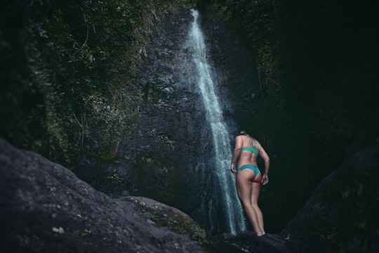
8 - Kaniakapupu
7 km away
Kaniakapūpū, known formerly as Luakaha, is the ruins of the former summer palace of King Kamehameha III and Queen Kalama on the island of Oahu in Hawaii.
View on Google Maps Book this experience
9 - Helicopter Tours in Oahu
15 km away
Watch the sun sink into the Pacific Ocean as you soar across the sky and experience Hawaii bathed in warm, golden light during this sunset helicopter tour of Oahu!There are few things more beautiful than seeing the sun set into the ocean, and when yo...
Book this experience
10 - Heʻeia State Park
Heʻeia State Park is an 18.5 acre state park located near Kaneohe on the windward shore of the Hawaiian island of Oahu. The park is located on Kaneohe Bay, between Heʻeia Fishpond and Heʻeia Kea small boat harbor.
View on Google Maps Book this experience
11 - The Byodo-In Temple
Learn more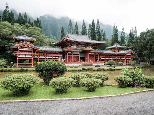
12 - Surfing in Oahu
14 km away
Surfing is an ancient and culturally significant water sport that has been practiced throughout Polynesia for thousands of years. As such, there is no better way to immerse yourself into Hawaiian culture than by getting out on the water and learning ...
Book this experience
13 - Na Mokulua
11 km away
Nā Mokulua, or just Mokulua are two islets off the windward coast of Oahu in the Hawaiian Islands. The islets are often photographed, and are located about 0.75 miles off Kaʻōhao, a neighborhood of Kailua, Hawai‘i.
View on Google Maps Book this experience
14 - Koʻolau Range
11 km away
Koʻolau Range is a name given to the dormant fragmented remnant of the eastern or windward shield volcano of the Hawaiian island of Oʻahu. It was designated a National Natural Landmark in 1972.
View on Google Maps Book this experience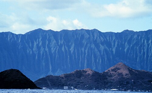
15 - Boat Tours in Oahu
14 km away
Watch the sun set over Oahu while taking in panoramic views of the beautiful Waikiki coastline and even whalespotting during this sunset catamaran cruise departing from Honolulu!The world-famous stretch of Waikiki, with its skyscrapers, thin crescent...
Book this experience
16 - National Memorial Cemetery of the Pacific
12 km away
The National Memorial Cemetery of the Pacific is a national cemetery located at Punchbowl Crater in Honolulu, Hawaii. It serves as a memorial to honor those men and women who served in the United States Armed Forces, and those who have given their lives in doing so.
View on Google Maps Book this experience
17 - Kualoa Regional Park
12 km away
Kualoa Regional Park is located at Kāneʻohe Bay, on the island of Oahu in the U.S. state of Hawaii. The park covers 153 acres across the road from the Pali-ku of the Koʻolau Range.
View on Google Maps Book this experience
18 - Mokoliʻi
12 km away
Mokoliʻi, also known as Chinaman's Hat, is a basalt islet in Kāneʻohe Bay, Hawaii. Mokoliʻi is part of Kualoa Regional Park and located 1⁄3 mile offshore of Kualoa Point, Oahu.
View on Google Maps Book this experience
19 - Liliuokalani Park and Gardens
12 km away
Foster Botanical Garden, measuring 13.5 acres, is one of five public botanical gardens on Oahu. It is located at 50 North Vineyard Boulevard, Honolulu, Hawaii, United States, near Chinatown at the intersection of Nu'uanu Avenue and Vineyard Boulevard.
View on Google Maps Book this experience
20 - Hawaiian Mission Houses Historic Site and Archives
13 km away
The Hawaiian Mission Houses Historic Site and Archives Honolulu, Hawaii, was established in 1920 by the Hawaiian Mission Children's Society, a private, non-profit organization and genealogical society, on the 100th anniversary of the arrival of the first Christian missionaries in Hawaiʻi.
View on Google Maps Book this experience
21 - Aloha Tower
13 km away
The Aloha Tower is a retired lighthouse that is considered one of the landmarks of the state of Hawaii in the United States. Opened on September 11, 1926, at a then astronomical cost of $160,000, the Aloha Tower is located at Pier 9 of Honolulu Harbor.
View on Google Maps Book this experience
22 - Hawaii State Capitol
13 km away
The Hawaii State Capitol is the official statehouse or capitol building of the U.S. state of Hawaii. From its chambers, the executive and legislative branches perform the duties involved in governing the state.
View on Google Maps Book this experience
23 - Kualoa Ranch
13 km away
Kualoa is a 4,000-acre private nature reserve and working cattle ranch, as well as a popular tourist attraction and filming location on the windward coast of Oʻahu in Hawaiʻi. It is about 24 miles from Honolulu, and 32 miles from Haleiwa.
View on Google Maps Book this experience
Disover the best Instagram Spots around Kaneohe here
Book Tours and Activities in Kaneohe
Discover the best tours and activities around Kaneohe, United States and book your travel experience today with our booking partners
Pictures and Stories of Kaneohe from Influencers
2 pictures of Kaneohe from Drew Farwell, Tom Henderson, and other travelers
Plan your trip in Kaneohe with AI 🤖 🗺
Roadtrips.ai is a AI powered trip planner that you can use to generate a customized trip itinerary for any destination in United States in just one clickJust write your activities preferences, budget and number of days travelling and our artificial intelligence will do the rest for you
👉 Use the AI Trip Planner
Why should you visit Kaneohe ?
Travel to Kaneohe if you like:
⛰️ Hill stationWhere to Stay in Kaneohe
Discover the best hotels around Kaneohe, United States and book your stay today with our booking partner booking.com
More Travel spots to explore around Kaneohe
Click on the pictures to learn more about the places and to get directions
Discover more travel spots to explore around Kaneohe
⛰️ Hill station spots ⛰️ Hill spots Recreational fishing spots 🏰 Temple spotsTravel map of Kaneohe
Explore popular touristic places around Kaneohe